


Cap Sicié -ch.littoral

soca
User
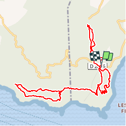

Length
12.4 km

Max alt
339 m

Uphill gradient
624 m
Km-Effort
21 km

Min alt
59 m

Downhill gradient
624 m
Boucle
Yes
Creation date :
2018-06-26 12:59:09.153
Updated on :
2018-06-26 12:59:09.153
4h23
Difficulty : Medium

FREE GPS app for hiking
 SityTrail
IGN / Geographical institutes
SityTrail Plus
The world is yours!
About
Trail Walking of 12.4 km to be discovered at Provence-Alpes-Côte d'Azur, Var, La Seyne-sur-Mer. This trail is proposed by soca.
Positioning
Country:
France
Region :
Provence-Alpes-Côte d'Azur
Department/Province :
Var
Municipality :
La Seyne-sur-Mer
Location:
Unknown
Start:(Dec)
Start:(UTM)
732726 ; 4771307 (31T) N.
Comments